Friday, August 13, 2010

New MobileMapper 100 GPS Unit - Jon is first to test in US


Hi Everyone,

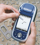
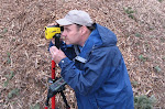
I was able to test the new MobileMapper 100 GPS unit from Ashtech last week. That unit was the only one in the US; and I was the first to get to test it! Not wanting to baby it, I took it straight to the Clackamas GPS test course east of Portland, Oregon. The course is a tough one, with big, tall timber.

The MobileMapper 100 performed flawlessly. I have not summarized accuracy tests yet, although it definitely beat every other unit I have ever tested at Clackamas. Boy does it track satellites! It tracks both US and GLONASS satellites which means it never had less than 10 satellites even on the toughest points. PDOP was almost always below 2.0 and sometimes as low as 1.6

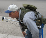
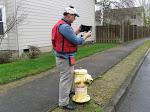
The picture above shows me with the MobileMapper 100 and the external antenna. I did the Clackamas test course twice with the external antenna and twice with the internal antenna. the internal antenna is a precision unit and it did as well as the much larger and heavier external unit.

I have ordered my own MobileMapper 100 and hopefully it will arrive by mid September. The production units will be available in September or October.

All for now! Call me at 503-521-0888 if you have questions on the MobileMapper 100.

Jon Aschenbach

Wednesday, May 19, 2010

Inland Empire SAF meeting May 20-22, 2010

Hi everyone,

I will be exhibiting at the Inland Empire SAF meeting in Wallace, Idaho this Thursday and Friday. The meeting is centered around discussions of the 1910 Idaho fires that burned 3.1 million acres. The fires were devastating, killing dozens of fire fighters and local people. This year is the 100th anniversary of the fires.

This meeting will be a good one, with a great agenda and excellent attendance. I hope to see some of you at the meeting.

Jon Aschenbach

Wednesday, April 28, 2010

Important News on the WAAS satellites

We just learned last week that one of our two WAAS satellites is going to be turned off in a couple of weeks. The problem is that the people on the ground who control the satellite have lost the ability to keep the satellite in it's precise orbit path. Once it strays too far out of its orbit path, it will just be shut down.

Hawaii and western Alaska are the states that will suffer the most from the lost WAAS satellite, because the remaining healthy WAAS satellite is the one further east.

Luckily, we still have one WAAS satellite available to us in the continental US. It is high above the horizon and will continue to provide excellent service to anyone using an SXBlue GPS unit or other GPS that utilizes WAAS.

Jon Aschenbach
Resource Supply, LLC

Saturday, February 6, 2010

All of Oregon Covered in 2009 NAIP Imagery

I finally received the rest of the 2009 NAIP imagery for the final 14 counties in Oregon. More information can be viewed on my website at www.resourcesupplyllc.com The imagery is available for immediate shipment in the Original version or in the Pocket PC version.

Next week I will be at the Sierra Cascade Logging Conference in Redding, California. I have been exhibiting at this conference for most of the past 20 years. If any of you will be attending, please stop by the Laser Technology Booth. I will be in their booth, helping with the TruPulse Lasers, RD1000 BAF scope, and other Laser Technology equipment. I will also have some of my Magellan, (now Ashtech) equipment on display.

After the Sierra Cascade Logging Conference, you can find me at the Oregon Logging conference in Eugene, Oregon. Dates are February 25-27 at the Lane County Fairgrounds. I'll be in my own booth, which will be next to the Laser Technology booth.

Have Fun!

Jon

Thursday, December 10, 2009

2009 NAIP Imagery Available Now


The 2009 NAIP imagery is available for all of Washington and 22 counties in Oregon. The imagery is one meter resolution, color, orthorectified, and available in the CCM (compressed county mosaic) format. That basically means you can bring up an entire county on your laptop, desktop, or pocket PC in ArcPad or ArcGIS.

The imagery is beautiful, having better colors and better resolution than the previous 2005 and 2006 imagery. File sizes are a bit larger, with some of the really big counties being broken into three pieces instead of two. Douglas county in Oregon is an example.

The imagery is available in the original UTM format or enhanced to run on a Pocket PC in state plane coordinates.

Call me at 503-521-0888 if you have questions about the NAIP imagery.

The cold weather has been interesting. I love the bright days. I heat with firewood and it has been a bit of a strugle to keep the fireplace insert filled with wood. It sure is nice to have a nice warm fire going.

Jon

Sunday, September 20, 2009

New Method to Hold GPS Antenna


Hi Everyone,

I have been working with Doug Allen to make a better antenna mount for GPS antennas. Doug is a professional timber cruiser with many years of field experience. He uses ArcPad on a Nomad Pocket PC, with an SXBlue II GPS unit providing the sub meter GPS positions. Doug and I have been talking about how to set up an antenna mast in the best possible position, to make it easily accessable for raising and lowering the antenna. Most people put the antenna mast in a narrow pocket on the back of their vest. This makes it hard to reach and the antenna mast catches on everything in the woods.

Doug has been setting up his new vest, an army surplus model. I suggested that the antenna mast be positioned in the front of the vest, making it easier to adjust for height. That's what Doug did, and it works perfect.

The mast can be raised with a simple tug on the top of the mast. It does not have to be locked into any one position, as friction will hold it up in the air. The antenna cable is just twirled around the mast so it goes up an down with ease.

When Doug bends over to go under a branch or some brush, the antenna is below his head and he goes right through. With an antenna mast on your back, you invariably get it caught up on something; not this one!

All for tonight. Let me know what you think of this design for an antenna mast.

By the way, the antenna mast is a Seco mast which extends from 16 inches to 36 inches. The actual antenna mounts on a 1/2 inch thick piece of plastic that I made. The plastic is totally indestructible and it is drilled and tapped for the 5/8 x 11 thread mount on the end of the antenna mast.

trivia question: Who invented Basketball? Hint, it wasn't the US.

Jon Aschenbach 503-521-0888

Monday, September 14, 2009

NAIP Imagery for Oregon and Washington in 2009

Hi everyone,

I just confirmed that Oregon and Washington are both being flown this year for a new set of 1 meter color orthorectified NAIP imagery. More information will be posted as it becomes available. It appears that the imagery will be available in a couple of months, rather than at the end of the year.

The NAIP imagery is wonderful for use on pocket PCs when entire counties need to be brought up. I will re-compress the imagery to allow use on commonly used pocket PCs such as the Nomad, Recon, Mobile Mapper 6 and others.

The imagery will probably be in JPEG 2000 format, rather than MrSID format. This does not have any real impact on the user. I re-compress the imagery in JPEG 2000 format anyway.

For anyone needing better resolution, the imagery from Eagle Digital Imaging is a great option. If you want your tree farm flown this year, contact them as soon as possible to make sure the imagery is collected before shadows get too long. Eagle Digital imagery is 2 foot resolution and the horizontal placement accuracy is 4 meters or better.

Last weeks trivia questions answer: The US uses 10 percent of the world's salt production for winter time salting of roads. (Fortunately, not in Oregon and Washington)

Have fun! Call me at 503-707-6236 if you have any questions.

Jon Aschenbach