Sunday, September 20, 2009

New Method to Hold GPS Antenna


Hi Everyone,

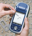
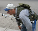
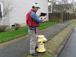
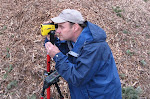
I have been working with Doug Allen to make a better antenna mount for GPS antennas. Doug is a professional timber cruiser with many years of field experience. He uses ArcPad on a Nomad Pocket PC, with an SXBlue II GPS unit providing the sub meter GPS positions. Doug and I have been talking about how to set up an antenna mast in the best possible position, to make it easily accessable for raising and lowering the antenna. Most people put the antenna mast in a narrow pocket on the back of their vest. This makes it hard to reach and the antenna mast catches on everything in the woods.

Doug has been setting up his new vest, an army surplus model. I suggested that the antenna mast be positioned in the front of the vest, making it easier to adjust for height. That's what Doug did, and it works perfect.

The mast can be raised with a simple tug on the top of the mast. It does not have to be locked into any one position, as friction will hold it up in the air. The antenna cable is just twirled around the mast so it goes up an down with ease.

When Doug bends over to go under a branch or some brush, the antenna is below his head and he goes right through. With an antenna mast on your back, you invariably get it caught up on something; not this one!

All for tonight. Let me know what you think of this design for an antenna mast.

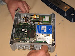
By the way, the antenna mast is a Seco mast which extends from 16 inches to 36 inches. The actual antenna mounts on a 1/2 inch thick piece of plastic that I made. The plastic is totally indestructible and it is drilled and tapped for the 5/8 x 11 thread mount on the end of the antenna mast.

trivia question: Who invented Basketball? Hint, it wasn't the US.

Jon Aschenbach 503-521-0888

Monday, September 14, 2009

NAIP Imagery for Oregon and Washington in 2009

Hi everyone,

I just confirmed that Oregon and Washington are both being flown this year for a new set of 1 meter color orthorectified NAIP imagery. More information will be posted as it becomes available. It appears that the imagery will be available in a couple of months, rather than at the end of the year.

The NAIP imagery is wonderful for use on pocket PCs when entire counties need to be brought up. I will re-compress the imagery to allow use on commonly used pocket PCs such as the Nomad, Recon, Mobile Mapper 6 and others.

The imagery will probably be in JPEG 2000 format, rather than MrSID format. This does not have any real impact on the user. I re-compress the imagery in JPEG 2000 format anyway.

For anyone needing better resolution, the imagery from Eagle Digital Imaging is a great option. If you want your tree farm flown this year, contact them as soon as possible to make sure the imagery is collected before shadows get too long. Eagle Digital imagery is 2 foot resolution and the horizontal placement accuracy is 4 meters or better.

Last weeks trivia questions answer: The US uses 10 percent of the world's salt production for winter time salting of roads. (Fortunately, not in Oregon and Washington)

Have fun! Call me at 503-707-6236 if you have any questions.

Jon Aschenbach

Thursday, September 10, 2009

New Videos on www.ruggedready.com

Hi everyone,

I had my son download three more videos onto my www.ruggedready.com web site. One is on the ProMark 500 survey grade GPS unit. The ProMark 500 gives centimeter accuracy using a real time network such as the one in Oregon or Washington. It's fun to use because you can be collecting centimeter accurate points within minutes of turning it on.

The other two new videos are 1) Using OPUS and 2) What is WGS84? Both of these videos are by Joe Sass and Phil Stevenson with Magellan Professional. They really provide a lot of information in a couple of short videos. Click here to go to www.ruggedready.com Then click on the Survey Grade GPS tab.

Speaking of my son, he just left for a trip to Japan and Taiwan this morning. He'll be gone a month, resulting in my video production coming to a temporary halt. Adam does the filming, video production, and then posts the videos on the web site. I have lots more videos that I want to make, but it will have to wait.

Upcoming conferences include the NW ESRI GIS conference in Sunriver the week of October 13 - 16. I will be exhibiting there, plus I might be a presenter. My presentation, if accepted, will be on using ArcPad to map pond-lilies in Cheadle Lake using a TruPulse 360B. It's an example of a mapping project that would have been difficult, if not impossible, without the TruPulse 360B and ArcPad.

Trivia question: How does the US use 10% of the worlds salt production every year? Answer next week! (It's not "on french fries"!

All for now!

Jon Aschenbach